
Landforms: Earth’s Living Canvas
📚 Chapter Index
🎯 Learning Objectives — After this chapter you will be able to:
- Understand the theory of plate tectonics and how tectonic plates shape the Earth’s surface
- Describe the layered interior structure of the Earth — crust, mantle and core
- Explain the role of weathering, erosion and agents of gradation in modifying landforms
- Identify the work of rivers, glaciers, wind and waves as agents of denudation
- Distinguish between mountains, plateaus and plains as major landforms of the Earth
- Understand natural disasters — earthquakes, landslides, avalanches, GLOFs and duststorms — their causes, effects and mitigation strategies
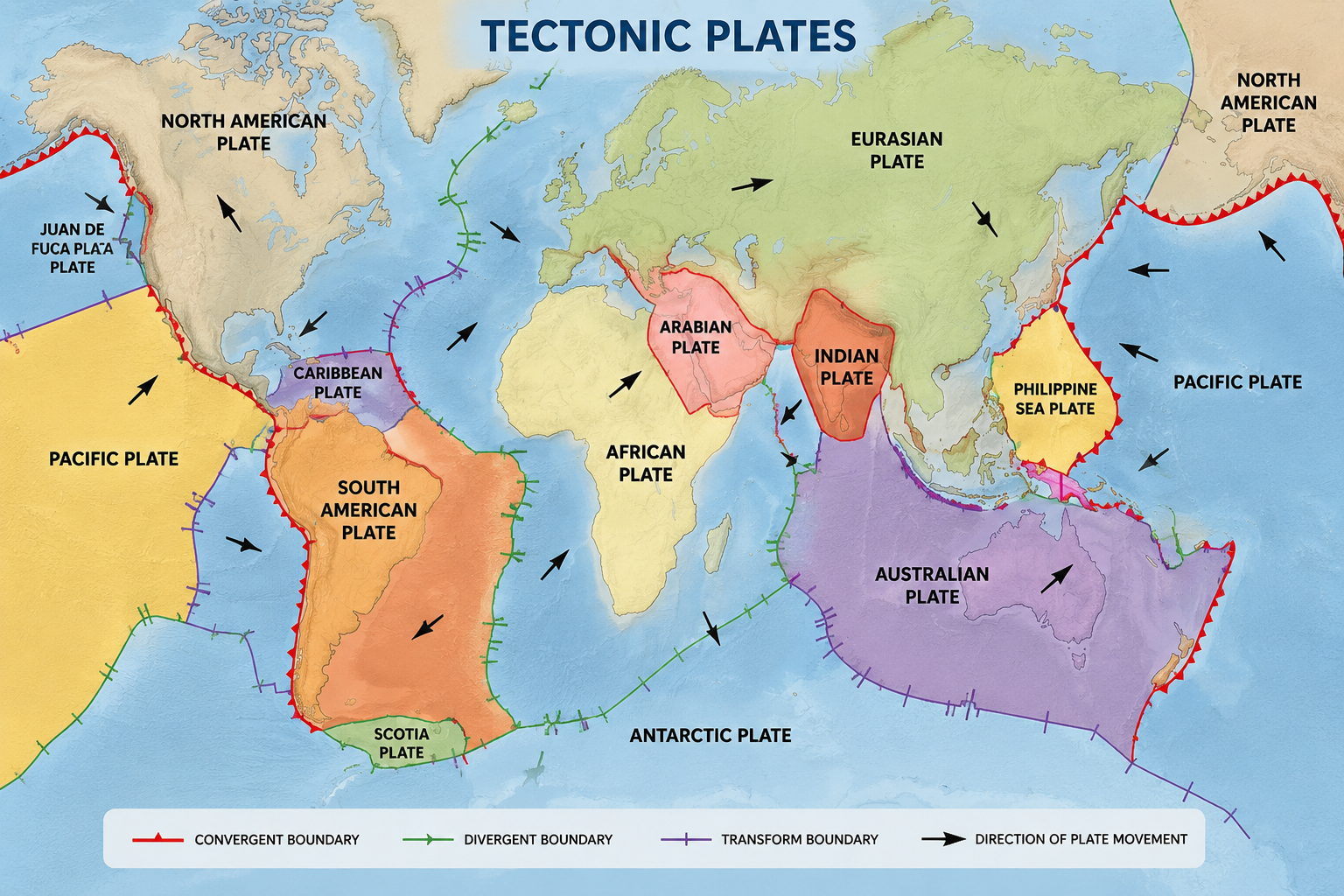
Distribution of Major Tectonic Plates
- Plate tectonics is one of the most important scientific theories in Earth science — it explains how the Earth’s surface is constantly changing over time.
- The Earth’s outer layer, the lithosphere, is divided into large and small plates that move over the semi-fluid layer beneath them — the asthenosphere.
- The Continental Drift Theory was proposed by Alfred Wegener in 1912 — he suggested all continents were once joined in a single landmass called Pangaea and later drifted apart.
- Evidence for continental drift: matching coastlines, fossils and rock formations — but Wegener could not explain the mechanism behind the movement.
- The Seafloor Spreading Theory, proposed by Harry Hess and Robert S. Dietz in the 1950s, provided the missing mechanism — new oceanic crust is formed at mid-ocean ridges due to volcanic activity; supported by magnetic striping on the ocean floor.
- Convection Currents in the mantle: heat from Earth’s core creates convection currents — hot material rises, cooler material sinks, creating circular motion that drives plate movement.
- Types of plate boundaries: Divergent (plates move apart), Convergent (plates collide), Transform (plates slide past each other).
- This theory helps explain earthquakes, volcanic activity, mountain formation and ocean trench formation — making it one of the most important theories in geology.
📝 Questions — Plate Tectonics
Who proposed the Continental Drift Theory? What was Pangaea?
Show Answer
What are the three types of plate boundaries? Give one feature of each.
Show Answer
Why could Wegener not convince scientists with his Continental Drift Theory despite providing evidence?
Show Answer
How do convection currents in the mantle drive tectonic plate movement?
Show Answer
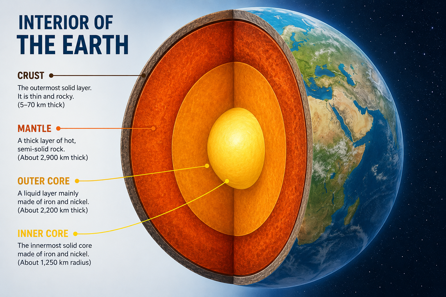
Interior of the Earth — Crust, Mantle and Core
- Our earth has a layered structure comprising three main layers: Crust, Mantle and Core.
- The Crust is the solid outer covering — average thickness varies from 5 to 40 kilometres; thicker under continents, thinner under oceans; made up of a great variety of rocks; sustains all life.
- In between the crust and the mantle is the Mantle — average thickness about 2,900 km; divided into upper mantle and lower mantle.
- The crust is separated from the mantle by the Mohorovicic Discontinuity (Moho) — named after geologist Andrija Mohorovicic who discovered it.
- The innermost shell is called the Core — about 3,500 km thick; the densest layer, made up of metals; sometimes called the metallic core.
- The core is divided into: Outer core — mainly composed of iron; exists in a liquid state; and Inner core — composed of nickel and iron; behaves like a solid due to extremely high pressure.
- Because of the presence of metals (nickel and iron), the earth acts like a magnet.
- As we move towards the centre of the earth, the density of the different layers goes on increasing.
- Temperature increases at the rate of 1°C for every 32 metres as one moves down the earth’s surface.
📝 Questions — Interior of the Earth
Name the three main layers of the Earth and give the thickness of the mantle.
Show Answer
What is the Mohorovicic Discontinuity? What does it separate?
Show Answer
Why does the outer core remain liquid while the inner core is solid, even though the inner core is at a higher temperature?
Show Answer
Why does density increase as we move towards the centre of the Earth?
Show Answer
An Effect of Weathering and Erosion
- Various processes go on changing the surface of the earth constantly — some work beneath the crust (volcanic activity, earthquakes), others work on the surface (weathering, erosion, mass movements).
- External processes play a vital role in modifying the surface of the earth and help in the formation of soil.
- Natural processes which take place gradually on the surface of the earth are called external processes — weathering, erosion and mass movements are some such external processes.
- The process by which rocks exposed on the surface get broken into smaller pieces in situ (in the same place) is known as weathering.
- Change in temperature and pressure — continuous heating and cooling of rocks makes them break apart.
- Water collects in cracks and pores of rocks; when temperature falls, it freezes and expands, widening cracks — called frost-action.
- Air loaded with sand works like sandpaper — strikes rock surfaces especially during storms, abrading and breaking rocks.
- Seeds deposited in small holes in rocks — roots of plants go deep into cracks and break rocks into pieces.
- Animals and humans also break rocks into pieces by their mechanical actions.
- 1. Physical Weathering — disintegration of rocks without any change in chemical composition; peeling of outer layers called exfoliation, common in granitic rocks; in cold lands, water freezes in cracks and expands — called frost-action.
- 2. Chemical Weathering — due to chemical reaction of water or air, portions of rocks are dissolved producing cavities, sinkholes and caverns; soluble minerals like rock-salt, limestone and sandstone dissolve into water and are removed.
- 3. Biological Weathering — animals and plants break rocks; roots of plants produce acidic juices which cut into rock-material and slowly break the rocks; burrowing animals like rabbits and rats also contribute.
- The act of carrying away the weathered particles from one place to another is called erosion.
- Rivers, rainwater, glaciers, waves and winds carry away weathered particles from place to place.
- Rate and ratio of erosion depends upon: (i) Rainfall; (ii) Temperature; (iii) Slope of land; (iv) Type of soil; (v) Presence of vegetation cover; (vi) Change in land use pattern.
- Where the Great Himalayas now stand, there was once a deep sea called ‘Tethys’ — proof of the power of weathering and erosion over millions of years.
- Mass movements bring changes in the earth’s surface — caused by gravity which pulls all materials downwards.
- Very common in mountainous regions like Uttarakhand, Himachal Pradesh and Jammu and Kashmir.
- Landslide — dry soil and rock pieces move down a steep slope.
- Earth flow — rock materials like clay and silt, saturated with water, move down a gentle slope.
- Mud-flow — water-saturated rock debris move down channels on steep hillsides.
- Denudation means making nude or bare — five agents: Rivers, Rain water, Ice or Glaciers, Sea waves and Winds.
- 1. Rivers — transport huge quantities of broken rocks to lowlands; erode land into gorges and valleys.
- 2. Rainwater — seeps underground through fissures; forms springs, caves and other landscape features in hilly areas with soluble rocks like limestone.
- 3. Ice or Glaciers — moving mass of ice on mountains; when they melt they give birth to rivers; erodes V-shaped valleys into U-shaped valleys.
- 4. Seawaves — causes erosion of the coast; also deposits material along the shore — work comprises erosion, transportation and deposition.
- 5. Winds — most significant in desert areas like Thar Desert in Rajasthan and Sahara in Africa; remove dry particles of dust or sand very easily.
- By cutting trees indiscriminately, man turns the land into wasteland — no trees means no rain, land is automatically degraded.
- Indiscriminate building activities not only swallow the land but render surrounding land degraded.
- Dirty and poisonous effluents from factories collecting in surrounding areas completely degrade land.
- Dumping of city waste on any land completely leads to its degradation.
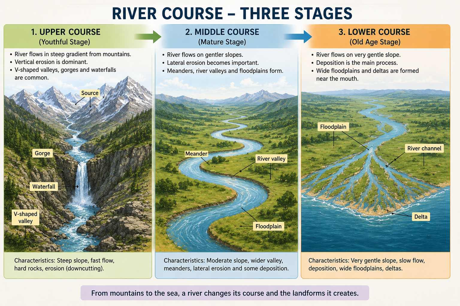
The Course of a River from its Source in the Mountains to its Mouth at the Sea
- (1) The Upper Course or the Mountain Stage — slope is very steep; river rushes down with great speed; busy in erosion and transportation; develops gorges, V-shaped valleys, waterfalls and rapids; a series of rapids are called cascades; Angel Falls (Venezuela — 980 metres) is the highest waterfall in the world.
- (2) The Middle Course or the Plain Stage — slope is not steep; river becomes gradual; overflows its bank depositing alluvial sediments forming flood plains; irregularities of ground force river to swing making big loops called meanders.
- (3) The Lower Course or the Delta Stage — last stage before river merges into sea; speed slows down; river divides into many channels called distributaries; deltas formed — contain deposits of alluvium and are very fertile.
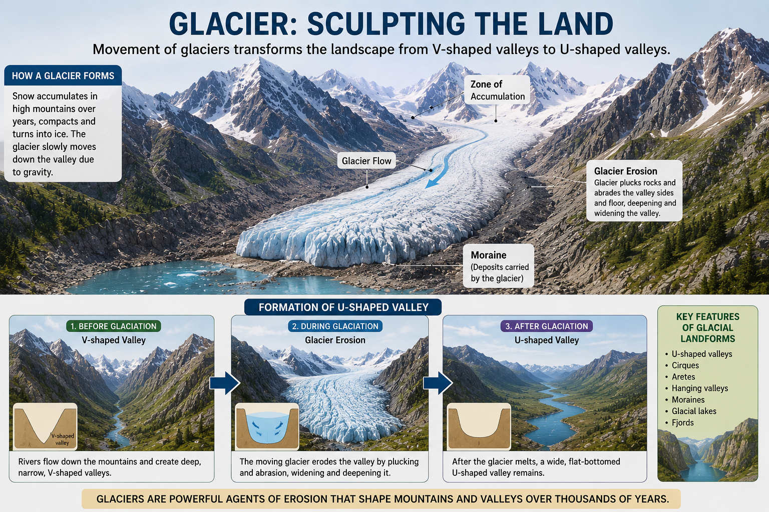
Mountain Glacier Moving Through a Valley
- Mountain Glaciers — move down from mountain tops along valleys; melt at edges giving birth to rivers; Rivers Ganga and Yamuna arise from melting of mountain glaciers; erodes V-shaped valley into U-shaped valley.
- Continental Glaciers — comparatively bigger in size and slower in movement; occupy large areas exceeding thousands of square kilometres; thick ice sheets covering entire land surface; generally occur in Polar Regions.
📝 Questions — Weathering, Erosion & River Work
What is weathering? How is it different from erosion?
Show Answer
Name the three types of weathering and give one example of each.
Show Answer
How does the Tethys Sea prove the power of weathering, erosion and tectonic forces over millions of years?
Show Answer
How does a glacier change a V-shaped valley into a U-shaped valley? Distinguish between mountain and continental glaciers.
Show Answer
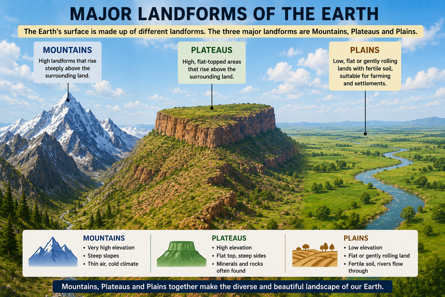
Major Landforms of the Earth — Mountains, Plateaus and Plains
- Mountains — high landmass with sharply sloping surfaces; three types: Fold Mountains (Himalayas, Alps, Appalachians, Ural); Block Mountains (Rhine valley, Vosges); Volcanic Mountains (Mt. Kilimanjaro — Africa, Mount Fujiyama — Japan). Young mountains like Himalayas have pointed peaks; old mountains like Aravalli have rounded tops due to erosion.
- Plateaus — broad, level stretch of upland; also called tableland; the Deccan Plateau extends over thousands of kilometres in India; the Tibet Plateau is the highest in the world — called the ‘Roof of the World’; generally rich in mineral deposits.
- Plains — flat, low-lying vast expanse of land; formed by major rivers depositing silt; the Great Northern Plain of India is formed by deposits brought by river Ganga and her tributaries; the Hwang-Ho Plain (China) and Nile Valley Plain (Egypt) are also formed by rivers; plains are most suitable for human habitation — very thickly populated and fertile.
- Natural disasters are powerful events caused by natural processes of the Earth — widespread destruction, loss of life, and damage to the environment and property.
- Events such as earthquakes, landslides, avalanches, GLOFs and dust storms are examples of natural hazards that significantly affect human settlements and natural ecosystems.
- Understanding these disasters is important for disaster preparedness, risk reduction and effective management.
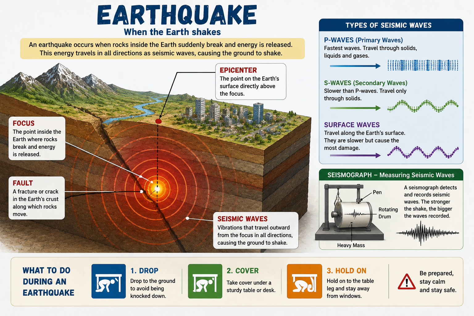
Earthquake — Epicenter, Focus and Seismic Waves
- Both the earth’s surface and interior are unstable — a sudden shaking of earth is a result of this instability and sudden release of energy.
- An earthquake causes trembling of the ground — buildings, trees, poles, dams begin to shake depending on the intensity.
- Man has not yet been able to invent any instrument that can predict the sudden outburst of earthquake energy — thus earthquake is regarded as a ‘sudden-onset hazard’.
- Over 1 million earthquakes occur at any time of the year in any part of the world including oceans — underwater earthquakes generate tsunamis.
- At least four dozen of these are described as highly hazardous to life and property of the people.
- In some western countries and USA, loud sirens have begun to be played as warning systems — but only few prove correct.
- Earthquake prone zones are today well marked in maps — settlements along geological fault-lines are most vulnerable to: earthquakes, landslides, and floods on account of breach of river banks or dams.
- Vulnerability depends on density of human settlements, soil and rock types — disintegrated rocks, sedimentary rock strata, alluvial and windblown soil are more vulnerable.
- A U.S. Geological Survey publication has shown that earthquake waves could shake a section of the crest 2000 metres thick.
- Geology of the area directly affects the intensity of the shock — steepness of the slope makes an earthquake shock more vulnerable.
- Panic: Vibratory waves cause panic among animals and humans alike — more damage is done by the panic.
- Physical damage: Collapse of buildings, cracks in ground, roads, bridges, walls, water tanks, bunds, rivers and dams.
- Public health: Hazards of disease on account of pollution of water bodies, breakdown of sewage and sanitary pipes, leading to epidemics.
- Civic services and conveyances: Water pipes, sewers, electric connections, roads disrupted — transmission towers and transformers also collapse.
- Disruption of economic activities: Farming, business, trade and services severely affected.
- Fire: Collapse of containers of inflammable substances like gas, petrol, kerosene, chemicals — tremors, heat and suffocation cause further damage.
- Engineered structures should be designed and built to withstand ground shaking — architectural and engineering inputs to improve building design and construction practice.
- Soil type must be analysed before construction — structures must not be built on soft soil; buildings on soft soil are more likely to get damaged even if the earthquake is not strong.
- Similar problem in alluvial plains and on river banks — heavy damages sustained when ground is soft.
- Public awareness and education: Information about time of actual shock and its intensity should be made public over radio, television and newspapers well in advance.
- Awareness should include: real cause of earthquake; Do’s and Don’ts during and after earthquake; awareness about risks and geology of the area; sensitization of engineers, architects, masons, doctors, government functionaries, bankers and financiers.
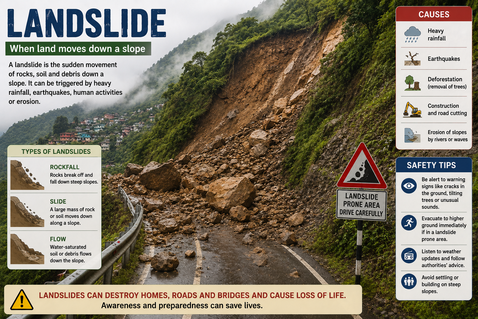
Landslides — Sudden Movement of Rock and Debris Down Slopes
- A landslide is a sudden movement of masses of rock, earth or debris with a force of their own weight down mountain slopes or river banks.
- People in hilly terrains or along river banks experience landslides often — also take place in areas of surface excavation for highways, buildings, fly-overs, underground railways, open pit mines.
- Landslides are a major natural disaster in the Himalayas, Western Ghats and North Eastern region covered by Pooravanchal Mountains.
- They cause damage to life, property, crops almost perennially — damage transportation and communication networks, causing long traffic jams.
- Landslides occur due to heavy rains, heavy snowfall, earthquakes, floods and volcanoes — most occur without any prior warning.
- There are no clearly established warning systems — hence, prediction of landslides is difficult.
- Areas of high risk can be determined by utilising information on geology, hydrology, vegetation cover, past occurrence and consequences in the region.
- Drainage corrections: Reduce water infiltration by allowing excess water to drain off; maintenance of natural drainage channels in vulnerable slopes.
- Engineered structures: Buildings with strong foundations; underground installations fitted flexibly to withstand forces caused by landslides.
- Retaining walls: Built along a slope to stop land from slipping — visible along roads at hill stations like Shimla.
- Building bylaws and codes: Bureau of Indian Standards and Indian Meteorological Department have prepared earthquake prone zone maps — codes and bylaws should be widely publicised and vigorously followed.
- Vegetation cover: The easiest, cheapest and most effective way of arresting landslides — through afforestation and avoiding grazing along mountain slopes.
- Land-Use Practices: Preserving and protecting natural vegetation; check/ban on deforestation; grazing of sheep and goats along mountain slopes should be banned; denuded upper slopes must be reforested; blockage of natural drainage should be avoided while constructing roads, canals, buildings.
- Hazard Mapping: Taken up by Government agencies, NGOs and others to locate regions prone to landslides — helps avoid construction of roads, buildings and bridges in landslide-prone areas.
- Awareness generation: Public awareness about causes, effects and areas prone to landslides is essential — imminent danger should be forecasted so that people may take safety measures.
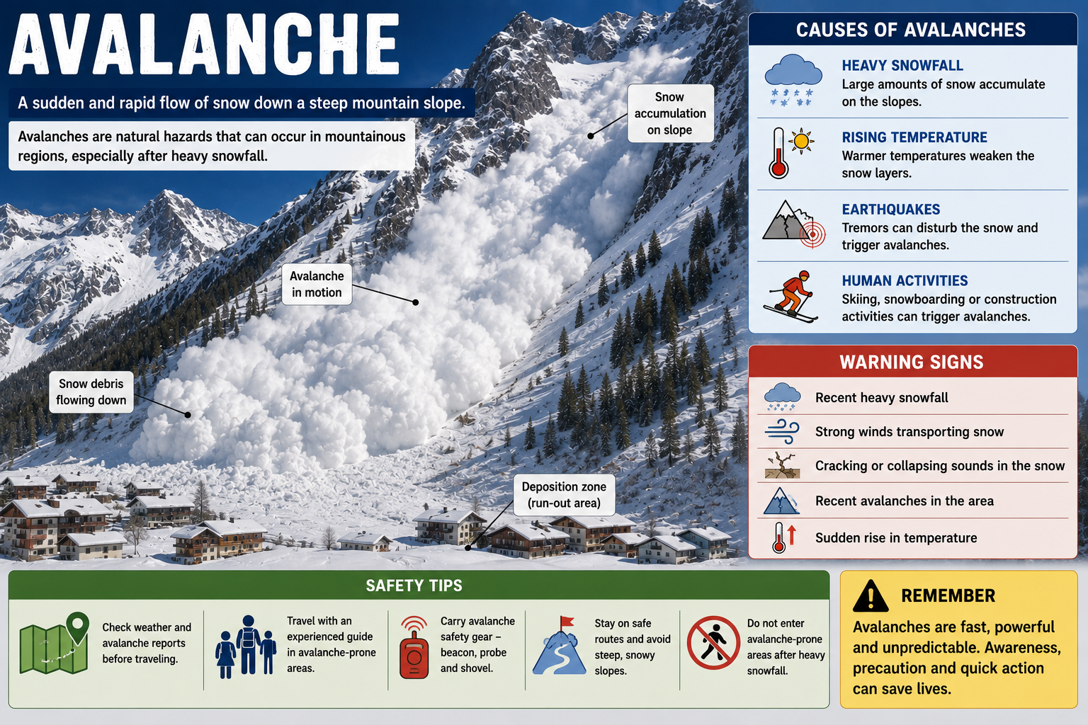
Avalanche — Sudden Flow of Snow and Ice Down a Mountain Slope
- An avalanche is a sudden and rapid flow of snow, ice, and sometimes rocks down a mountain slope.
- One of the most dangerous natural hazards in mountainous regions — can occur naturally or be triggered by human activities such as skiing, snowmobiling, or construction.
- 1. Heavy Snowfall: Large amount of fresh snowfall increases weight on existing snow layers, making them unstable.
- 2. Weak Snow Layers: If a weak layer forms beneath a heavier layer, it can collapse and trigger an avalanche.
- 3. Temperature Changes: Rapid warming causes snow to melt and lose bonding strength; sudden cooling creates fragile layers within the snowpack.
- 4. Steep Slopes: Most common on slopes between 30 and 45 degrees — gravity can easily pull the snow downward.
- 5. Human Activities: Skiers, mountaineers, vehicles or construction activities can disturb the snowpack and trigger avalanches.
- 6. Earthquakes or Vibrations: Natural vibrations from earthquakes or loud sounds may initiate avalanches in unstable snow conditions.
- 1. Monitoring and Early Warning Systems: Regular observation of snow conditions, weather forecasting and avalanche prediction systems help warn people in advance.
- 2. Controlled Avalanches: Authorities sometimes deliberately trigger small avalanches using explosives to prevent buildup of large, dangerous snow masses.
- 3. Protective Structures: Snow fences, retaining walls, avalanche barriers and diversion dams protect roads, railways and settlements.
- 4. Land Use Planning: Avoiding construction in high-risk avalanche zones reduces exposure to danger.
- 5. Afforestation: Planting trees on mountain slopes helps stabilise snow and reduce the likelihood of avalanches.
- 6. Public Awareness and Training: Educating people about avalanche risks, safety measures and rescue techniques (such as carrying avalanche beacons and probes) improves survival chances.
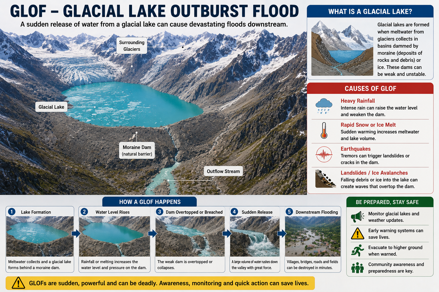
Glacial Lake — Massive Release of Water from a Glacial Lake
- A Glacial Lake Outburst Flood (GLOF) is a sudden and massive release of water from a glacial lake formed when melting glaciers accumulate water behind natural dams made of ice or loose rock debris (moraines).
- GLOFs are among the most dangerous natural hazards in mountainous regions — particularly in the Himalayas, Andes and other glacier-fed areas.
- When the natural dam fails, enormous volumes of water rush downstream causing severe flooding, destruction of infrastructure, loss of life and environmental damage.
- With rising global temperatures accelerating glacier melt, the risk of GLOFs has increased in many parts of the world.
- 1. Melting of Glaciers: Climate change leads to rapid glacier melting, increasing water volume and raising pressure on the natural dam.
- 2. Weak Moraine Dams: Glacial lakes blocked by loose piles of rocks and debris (moraines) which are unstable and prone to collapse.
- 3. Ice Avalanches or Landslides: Falling ice, rocks or landslides into the lake create large waves that overtop and breach the dam.
- 4. Earthquakes: Seismic activity can weaken or crack the natural dam, triggering sudden water release.
- 5. Heavy Rainfall or Rapid Snowmelt: Excess water from intense rainfall or sudden temperature rise increases water levels beyond the dam’s capacity.
- 1. Regular Monitoring and Risk Assessment: Satellite imagery, field surveys and remote sensing help identify potentially dangerous glacial lakes and monitor water levels.
- 2. Early Warning Systems: Installing sensors and alarm systems downstream alerts communities in case of sudden lake discharge.
- 3. Controlled Drainage: Constructing drainage channels, tunnels or siphon systems can safely reduce water levels in high-risk lakes.
- 4. Strengthening Natural Dams: Reinforcing moraine dams with protective structures reduces likelihood of sudden collapse.
- 5. Land Use Planning: Avoiding construction and settlement in flood-prone downstream areas minimises damage and loss.
- 6. Community Awareness and Preparedness: Educating local populations about evacuation routes and emergency response plans improves safety and resilience.
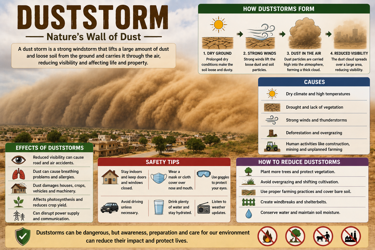
Duststorm — Strong Winds Lifting Large Amounts of Dust and Sand
- Duststorms are severe environmental disasters — strong winds lift large amounts of dust and sand from dry, bare soil into the atmosphere; reduce visibility and severely affect human life, agriculture, infrastructure and the environment.
- Most common in arid and semi-arid regions — pose serious health risks including respiratory problems such as asthma, bronchitis and eye infections; damage crops, degrade soil fertility and contaminate water sources.
- The primary causes are both natural and human-induced.
- Naturally — prolonged drought, high temperatures and strong winds create dry and loose soil conditions; sparse vegetation cover in desert regions also contributes.
- Human activities such as deforestation, overgrazing, poor agricultural practices, urbanisation and excessive land clearing further increase soil erosion and desertification.
- Climate change increases temperatures and alters rainfall patterns — leading to more frequent droughts and degraded land surfaces.
- Afforestation and reforestation programs should be promoted to stabilise soil and act as windbreaks.
- Sustainable land management — crop rotation, conservation tillage and controlled grazing help maintain soil structure and reduce erosion.
- Early warning systems and improved weather forecasting to alert communities in advance.
- Public awareness campaigns — staying indoors and using protective masks during storms.
- Regional cooperation is important because duststorms often cross national boundaries — sustainable environmental practices and strengthened disaster preparedness can significantly reduce harmful impacts.
📝 Questions — Landforms and Disasters
Name the three types of mountains with one example each. Why is Tibet Plateau called the ‘Roof of the World’?
Show Answer
Why are earthquakes called ‘sudden-onset hazards’? Name any four typical effects of earthquakes.
Show Answer
How does climate change increase the risk of GLOFs? Explain the chain of events.
Show Answer
How are duststorms both a natural and human-made disaster? What is the most effective long-term mitigation strategy?