
In June 2020, Indian and Chinese soldiers fought hand-to-hand in the Galwan Valley — at 14,000 feet above sea level, in sub-zero temperatures, with rocks and clubs — because neither side was permitted to use firearms under an agreement designed to prevent escalation. Twenty Indian soldiers died. China has never officially confirmed its casualties, though estimates range from 35 to 45. It was the deadliest clash on the India-China border in 45 years. Six years later, both sides have partially disengaged — but tens of thousands of troops remain deployed, billions of rupees of infrastructure is being built on both sides, and the fundamental dispute that caused the clash remains completely unresolved. This is the complete story of the India-China border dispute — where it came from, what happened, and where it stands today.
🗺️ What Is the LAC — The Line Nobody Can Agree On
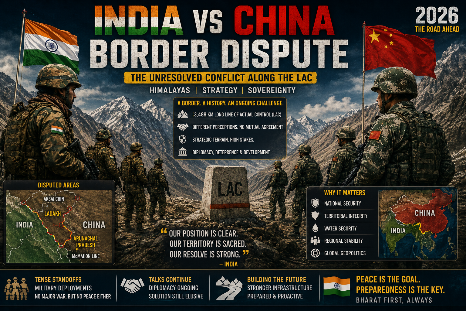
The India-China border dispute is fundamentally a dispute about a line that does not officially exist.
Unlike most international borders, the boundary between India and China has never been formally demarcated — agreed upon, surveyed, and marked on the ground. What exists instead is the Line of Actual Control (LAC) — a de facto boundary that represents where each side’s troops actually are, rather than where either side believes the border legally should be.
The LAC stretches approximately 3,488 kilometres across three sectors: the Western Sector (Ladakh), the Middle Sector (Himachal Pradesh and Uttarakhand), and the Eastern Sector (Sikkim and Arunachal Pradesh). The problem is that India and China have different understandings of where the LAC actually runs — in some areas differing by several kilometres, in others by tens of kilometres.
This ambiguity is not accidental. It is the product of 75 years of unresolved territorial claims, failed negotiations, and deliberate strategic ambiguity by both sides. And it is the root cause of every standoff, every patrol confrontation, and every clash that has happened between Indian and Chinese forces since 1962.
📜 The Historical Origins — How Did This Dispute Begin?
The dispute has three distinct origins — one in the West, one in the East, and one in the failures of diplomacy after Indian independence.
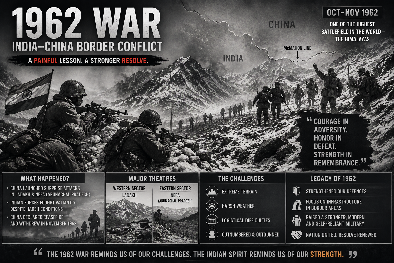
The Western Sector — Aksai Chin: Aksai Chin is a high-altitude desert plateau roughly the size of Switzerland — approximately 38,000 square kilometres. India claims it as part of Ladakh (formerly Jammu and Kashmir). China controls it and considers it part of Xinjiang. The British-era boundary in this sector was never precisely agreed upon — different maps showed different lines. China built a strategic road through Aksai Chin in the 1950s — connecting Tibet and Xinjiang. India discovered this road only in 1957. The shock of this discovery — that China had built a highway through what India considered its own territory without India even noticing — was one of the triggers for the 1962 war.
The Eastern Sector — Arunachal Pradesh: China claims approximately 90,000 square kilometres of Arunachal Pradesh as “South Tibet” — including the town of Tawang, which has significant religious importance as the birthplace of the sixth Dalai Lama. India contests this claim entirely — Arunachal Pradesh has been an integral part of India since independence, with its own state government, elected legislature, and 1.4 million Indian citizens. The boundary in this sector — the McMahon Line — was agreed between British India and Tibet in 1914 at the Simla Convention. China rejects this boundary on the grounds that Tibet was not sovereign and could not make such agreements.
The 1962 War — India’s Most Painful Military Memory: In October 1962, Chinese forces launched a massive military offensive across both the Western and Eastern sectors simultaneously. India’s military — inadequately equipped, poorly led, and operating on a strategy of “Forward Policy” that had placed small Indian posts deep in disputed territory — was overwhelmed. China advanced rapidly, then unilaterally declared a ceasefire and withdrew to approximately its pre-war positions. The war left India with a devastating defeat that transformed how the country thinks about its northern border — and about China — for generations.
🤝 The Peace Agreements — And Why They Failed
After 1962, both sides gradually rebuilt their relationship and established agreements designed to prevent another war.
The 1996 Agreement on Confidence Building Measures in the Military Field expanded on this — limiting military deployment near the LAC, setting rules for military exercises, air intrusions, and accidental border crossings. These agreements kept the border largely calm through the 1990s and into the mid-2000s.
The fragility of this arrangement became clear in 2017 — when Chinese troops with construction equipment began extending a road southward in Doklam, a plateau claimed by both China and India’s close ally Bhutan. Indian troops intervened to stop the construction. A 73-day standoff followed before both sides disengaged. Doklam was a warning. Three years later, the warning was ignored — with catastrophic consequences in the Galwan Valley.
⚔️ The Galwan Clash of 2020 — The Night Everything Changed

In April-May 2020, Chinese forces began moving into areas of eastern Ladakh that India considered clearly within its side of the LAC — including the Galwan Valley, Pangong Lake’s north bank, Hot Springs, Gogra, and Depsang Plains. This was not accidental patrol overlap. It was a coordinated, planned intrusion across multiple points simultaneously.
On the night of June 15, 2020, a violent confrontation erupted in the Galwan Valley. Chinese troops ambushed an Indian patrol near a tent India had erected in the valley. In the brutal hand-to-hand fighting that followed — with rocks, clubs, and improvised weapons, since the agreement prohibiting firearms in the border area was still technically in force — 20 Indian soldiers were killed, including Commanding Officer Colonel Santosh Babu.
The names of those who died are worth knowing: Colonel Santosh Babu, Havildar K. Palani, Naik Deepak Singh, Sepoy Gurtej Singh, Sepoy Oinam Sunil, and fifteen others — soldiers from Bihar, Punjab, Uttarakhand, Rajasthan, and across India. They died defending a river bank in a valley most Indians had never heard of.
China has never officially confirmed how many of its soldiers died in the clash. Intelligence estimates from multiple sources suggest Chinese casualties were significantly higher than India’s — possibly 35-45 soldiers. China awarded medals to several officers posthumously — indirect confirmation of casualties — but has maintained official silence on the numbers.
Galwan changed everything. India banned 59 Chinese apps including TikTok within weeks. Trade relationships were restricted. The “Hindi-Chini bhai bhai” rhetoric that had persisted despite multiple standoffs was finally abandoned. India began the largest military buildup along the LAC since 1962 — deploying tens of thousands of additional troops, upgrading roads, tunnels, and airbases at unprecedented speed, and prepositioning weapons and equipment for a sustained high-altitude confrontation.
🔄 Disengagement — What Has and Has Not Been Resolved
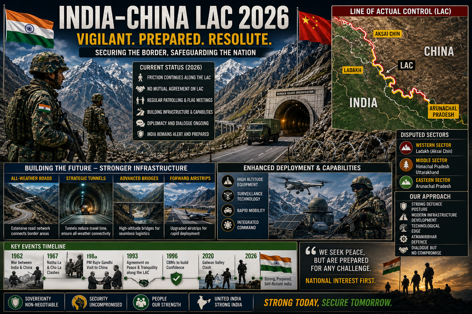
Through 21 rounds of Corps Commander-level military talks and multiple rounds of diplomatic negotiations, India and China have achieved partial disengagement from the friction points of 2020.
What has been resolved: Physical disengagement from most friction points. Resumption of patrolling in Depsang and Demchok. Restoration of some diplomatic contacts. High-level meetings between Prime Ministers Modi and Xi at multilateral forums.
What has not been resolved: The underlying boundary dispute. The question of which side’s interpretation of the LAC is correct. China’s infrastructure buildup in disputed areas. The new 2026 Chinese claim over the Shaksgam Valley. The approximately 50-60 traditional Indian patrolling points in eastern Ladakh that Indian soldiers could not access between 2020-2024. The broader strategic competition between the two countries that makes any permanent settlement politically difficult for both sides.
🏗️ The Infrastructure Race — India’s Most Important Response
The most significant and lasting Indian response to China’s border aggression has not been diplomatic — it has been concrete, asphalt, and steel.
India has been building border infrastructure at unprecedented speed since 2020 — roads, tunnels, bridges, airstrips, helipads, and military logistics infrastructure across the entire LAC. The most notable project is the Sela Tunnel in Arunachal Pradesh — inaugurated in 2024 — which provides all-weather road connectivity to Tawang even when the Sela Pass is snowbound. This single tunnel can move troops and equipment to the border in hours rather than days.
Other key infrastructure projects include the Zoji La tunnel in Ladakh (providing all-weather connectivity to Leh), upgraded Advanced Landing Grounds across Arunachal Pradesh, new military garrisons and ammunition depots in forward areas, and a network of Border Roads Organisation projects that have dramatically changed India’s military geography along the LAC.
China has simultaneously been building its own infrastructure — villages, roads, and military facilities on the Tibetan side of the LAC, including in areas that India disputes. The infrastructure race is in many ways more consequential than the diplomatic conversations — because infrastructure creates facts on the ground that outlast any particular government or agreement.
🌏 The Bigger Picture — What This Dispute Is Really About
The India-China border dispute is real — soldiers have died, territory is contested, and the disagreements are genuine. But it is also a proxy for something larger: the competition between two civilisational powers for primacy in Asia.
China views India’s growing strategic partnership with the United States, Japan, and Australia (the Quad) as an attempt to encircle China. It views India’s infrastructure buildup along the LAC as a threat. It uses border pressure as a tool to keep India focused on its northern frontier rather than expanding its strategic reach into Southeast Asia and the Indian Ocean — areas China considers its sphere of influence.
India views China’s border behaviour as part of a broader pattern of coercive diplomacy — the same approach China uses with Taiwan, in the South China Sea, and with smaller neighbours across Asia. India sees Galwan not as an isolated incident but as a deliberate signal that China will use force to assert territorial claims when it calculates the cost is acceptable.
The border dispute cannot be resolved without addressing this deeper strategic competition. And that competition — between Asia’s two most populous nations, both with nuclear weapons, both with historical grievances, and both with growing ambitions — is unlikely to be resolved by any agreement over where exactly the LAC runs through the Galwan Valley.
For more on India’s international relations and geopolitical context, read our complete guide on What Is BRICS — India’s Role in 2026.
❓ FAQs
What is the LAC and why is it disputed?
The Line of Actual Control (LAC) is the de facto border between India and China — approximately 3,488 kilometres long. It is disputed because India and China have different interpretations of where the line runs. The LAC has never been formally demarcated or agreed upon, leading to overlapping patrols, standoffs, and occasional clashes.
Why does China claim Arunachal Pradesh?
China claims approximately 90,000 square kilometres of Arunachal Pradesh as “South Tibet,” arguing that the McMahon Line boundary agreed at the 1914 Simla Convention is invalid because Tibet was not a sovereign entity. India rejects this claim — Arunachal Pradesh has been part of India since independence with its own elected government and 1.4 million Indian citizens.
How many Indian soldiers died in the Galwan clash?
20 Indian soldiers died in the Galwan Valley clash on June 15, 2020 — including Commanding Officer Colonel Santosh Babu. China has never officially disclosed its casualties. Intelligence estimates suggest Chinese deaths were significantly higher — possibly 35-45 soldiers.
Has India-China border dispute been resolved?
No. Physical disengagement from most 2020 friction points has been achieved through 21 rounds of Corps Commander-level talks. Patrolling in Depsang and Demchok resumed in January 2026. However the underlying boundary dispute — where the LAC actually runs — remains completely unresolved. Both sides continue to deploy large forces along the LAC.
What is Aksai Chin?
Aksai Chin is a high-altitude desert plateau of approximately 38,000 square kilometres. India claims it as part of Ladakh. China controls it and considers it part of Xinjiang. China built a strategic road through Aksai Chin in the 1950s connecting Tibet and Xinjiang — which India discovered only in 1957, contributing to the tensions that led to the 1962 war.
What is India doing to strengthen its border with China?
India has launched the largest border infrastructure programme since 1962 — building roads, tunnels, bridges, airstrips, and military logistics facilities across the LAC. Key projects include the Sela Tunnel in Arunachal Pradesh (providing all-weather access to Tawang), the Zoji La tunnel in Ladakh, upgraded Advanced Landing Grounds, and new military garrisons in forward areas.
📚 Sources
- IAS Babuji — India China Border Tensions 2026: Complete Analysis
- Vajirao Mandravi — Indo-China Border Dispute: Challenges in Defining the LAC
- PolSci Institute — The India-China Border Dispute: Historical Clashes and Current Status
- SPM IAS Academy — India China Border Dispute: LAC, History and Galwan Clash
2 Comments
Comments are closed.
[…] more on India’s border tensions and geopolitical context, read our complete guide on India China Border Dispute Explained and our analysis of India’s Role in BRICS […]
[…] For more on India’s constitutional debates, read our complete guide on Article 370 — The Complete Truth and our analysis of India-China Border Dispute. […]